Back to the start | Previous (Hare Mare Creek) | Next (South of Haast)
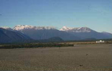
 1: View looking southeast across Haast River with ridges extending from the mountains with flat tops
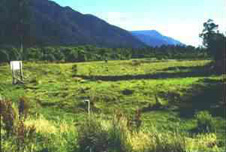
  2: Terrace created by motion on the Alpine Fault at Haast
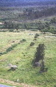
  3: Near the bottom of the photograph is a one of the trenches excavated across the Alpine Fault trace at Haast to determine recent past earthquakes which have accompanied surface rupture and displacement on the fault.
This view looking southeast across the Haast River to the Southern Alps shows how the ridges extending west from the mountains have noticeably flat tops. Other smaller ledges have been mapped lower down. Rounded quartz gravels found on these surfaces suggest they are remnants of marine benches cut at sea-level and lifted up by displacement on the Alpine Fault which runs at the base of the mountains. The age of the high platforms may be as young as 200,000 years. Other evidence gives an uplift rate here of c. 5mm/yr.
- Bull, W. B. & Cooper, A. F., 1987
The most recent trace of the Alpine Fault can be seen as a low, 2m high scarp running away from the signboard across the grassy field into the middle of the picture (the cow is standing on the top of the scarp). The left (SE) side is uplifted. Immediately behind the signboard is a terrace riser (edge) and the same riser may be seen between the signboard and the camera, offset dextrally by 16m in the last two earthquakes. Recent excavations across the fault trace here have provided clear evidence for three earthquakes since the terrace surface formed, each having about 8m of horizontal displacement.
Trenches were excavated across the Alpine Fault trace at Haast to determine recent past earthquakes which have accompanied surface rupture and displacement on the fault.
Back to the start | Previous (Hare Mare Creek) | Next (South of Haast)